
YNP Rim Circumnavigation 2023
June
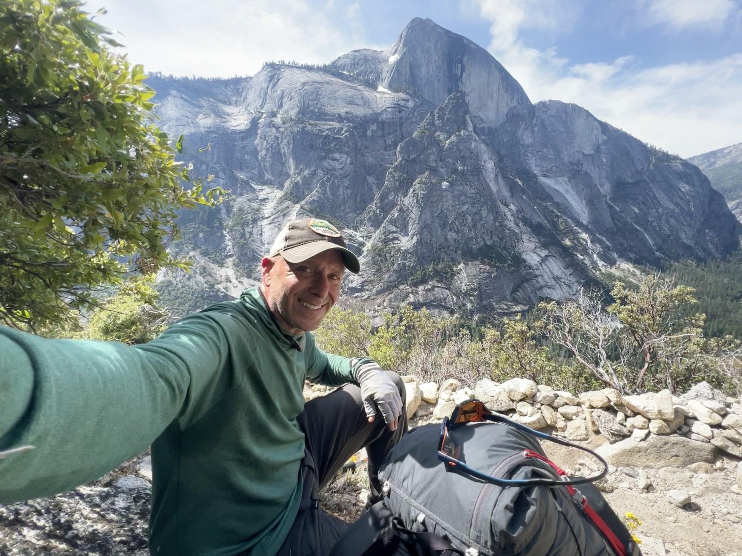
Adam on the Snow Creek Trail starting the 3-day loop around the rim of Yosemite Valley.
Is there a circumnavigation of the Yosemite Valley Rim in your future?
Alpine Adventure Coaching is a time-tested and trail-proven program to empower future long distance backpackers with the critical skills and confidence to plan, prepare, and safely complete a journey filled with diverse outdoor challenges on the when circumnavigating the Yosemite Valley Rim.
I first completed this loop back in 2015. At the time, the ranger who issued me the permit told me that, in her 11 years, no one had ever been permitted for this route. Once again in 2023, my issuing ranger told me the same thing. By the time I’d finished the 25,653 vertical feet in just two and a half days, I was reminded of the reason. This trip was meant as a training hike for my upcoming Colorado Trail thru-hike attempt. I wanted something that would challenge me physically and also let me fine tune my kit a bit more before my next adventure. In the end, this trip served both purposes perfectly.
Day 1
Daily Miles: 18.49
Total Miles: 18.49
Daily Elevation Ascended: 5942 ft
Daily Elevation Descended: 2549 ft
After picking up my permit at the Yosemite Wilderness Center I left my car in the Yosemite Village parking lot and walked the Valley Loop Trail past the Ahwahnee Hotel, past Mirror Lake directly under Half Dome, and took the Snow Creek Trail towards the top of the rim. This was a warm 2.2 mile climb of about 2500 ft. I passed a group of about 6 moving very slowly and as I crested the top, passed a single camper with her tent set up. The climb was beautiful with views up Tenaya Canyon down to the Valley and directly up at both Half Dome and North Dome. At times, when the angle was just right, I could make out hikers on the Half Dome cables a bit less than 2 miles away in the distance.
Snow Creek, like all the creeks I would come across, was heavily flowing. There was a lot of water coming down into the Valley and into the Merced River. Today, I was aiming for El Capitan by way of Yosemite Point and Yosemite Falls.
A thought came to me today. Every bit of water flowing that I’ll step over on this loop will end up in the Valley below. That’s a whole lotta water! Snow Plants dotted this part of the trail and would appear often on the rim throughout my hike.
Snow plants, also known as snow flowers or red snow, are fascinating organisms. They emerge from the ground as bright red, fleshy stalks covered in a waxy coating. Against the backdrop of white snow or forest duff, they create a beautiful contrast that catches the eye immediately. These plants lack chlorophyll and instead get their energy and nutrients by feeding off of fungi in the roots of trees which is a true win/win. By feeding off the fungi, they help regulate the fungal populations in their environment which enhances the forest ecosystem as a whole.
While I expected to find some snow in this section, there was none and the forest floor was covered in winter deadfall and pinecones.
I arrived at Yosemite Point around noon with some clouds starting to form. Predictions showed possible thunderstorms but not until tomorrow. Continuing, I crossed Yosemite Creek and worked my way into some flooded out areas taking care to keep the feet “dry.”
At about 5pm, I arrived atop El Cap. There were two climbers wandering around along with a couple a bit older than me looking for a camp spot. I never saw any of them after the first 15 minutes or so. I found a camp spot with an amazing view of Half Dome and the Valley below, set up my new SlingFin SplitWing tarp with my Borah Bivy, made some dinner and enjoyed the show. I never saw or heard anyone at all. It was the perfect campspot.
Snow Plant
Tarp Camping on El Cap
Yosemite Point
View from atop El Eap
Daily Miles: 24.55
Total Miles: 43.04
Daily Elevation Ascended: 5233 ft
Daily Elevation Descended: 5331 ft
Treating this trip like a training run, I woke at 4:15 in dark astronomical twilight. I broke down my camp, got dressed and packed my bag. Because I set my tarp up, and there was quite a bit of condensation, it took 60 minutes to hit the trail. By the time I started walking it was nautical twilight moving into civil twilight.
The first 1.5 miles were descended a bit along the rim of the canyon before ducking into the trees. This is where the snow started. It covered most of the trail and there were very few tracks. Many of the tracks went in circles and I decided to completely ignore the steps of others. The next mile took almost an hour. The snow was stable but finding my way through the bramble of berms and downed trees took a lot of time. When I finally broke out of the snow I was just about at the original Big Oak Flat road. I stopped to listen to the birdsongs and it inspired me:
Early morning birds
Sunlight kisses their music
Wake, to a new day
Here I will copy and paste my write-up (with some additions) from my 2015 trek.
The Rockslides trail only shows up on old and very old maps. The park service doesn’t advertise its existence or sometimes even acknowledge it. The “trail” is unmaintained and 142 years old. It was built in 1874 as the original Big Oak Flat Road into the Yosemite Valley and served as the main entrance for the next 64 years until the completion of the current Big Oak Flat Road. During the 1800s it served horses and wagons and in the early 1900s it was used by the first automobiles. It was built 100% by hand and muscle and is an extraordinary work of construction. The story goes like this; In the mid 1800s two investors made a bet to see who could complete the first road into the valley. The first investor was from San Francisco and called his road the Big Oak Flat Road (coming from the town of Big Oak Flat currently on Highway 120.) The second road was built by the town of Coulterville also entering the valley from the west. Halfway into the building of the roads, the San Francisco investor ran out of money and his laborers found work elsewhere. By the time he raised enough to continue his project, the other road was complete and he could find no skilled workers to finish construction. A few weeks later the investor met 5 Italians, just off a boat from Italy who just happened to be skilled rock wall builders. He immediately hired the five who skillfully and artistically built the remaining 30 rock walls without any concrete to finish the road from Gentry Pass into the valley. Once again the investor ran out of money, but the 5 Italians finished the work on a promise that they would be paid in full from the toll that was collected on the road. It took almost 5 years, but the Italians were paid in full. The road was completed in 1874. These would be the same rock walls I would search for during the next 3 hours of sometimes hiking and sometimes scrambling in order to reach the west rim of the valley. At times the road was just like that, a road. Broken asphalt peeking out from under leaves and dirt. Sometimes trees or manzanita would obscure the entire road or grow out from the middle of the path. Other times the road was a single track trail where rockslides had all but obliterated the road’s surface. And still other times, the road ceased to exist at all and its place were massive rockslides to scramble over, under and around all the while looking for the next rock wall built by those not-so-famous 5 Italians so many years ago. Each rock wall gave me not only a sense of direction, but also a sense of history.
The big difference between 2015 and 2023 is that there were hundreds of additional blow downs. These combined with making my way through the rockslides made the first 9 miles of my day take a grueling 7 hours. To put that into context, I would normally be able to cover 15-20 miles in that same amount of time.
Towards the bottom of the trail, the views that opened up to Bridalveil Falls and El Cap were stunning. And the entire time, the clouds continued to build.
In 2015, when I hiked this route clockwise instead of counter clockwise, I was able to wade through the Merced River to the other side of the Valley to join the next trail leading to the other rim. Not in 2023. The Merced was raging and I was forced to walk the road up to the first bridge in the park and then the Valley Loop trail back to Tunnel View Road. From there I stayed in the forest for about 100 yards until the Pohono Trail peeked out of the trees and I joined it for the remainder of the day.
The Pohono Trail first appeared on a map in 1896 but the original builder and date of construction are uncertain. It was originally a Native American trail which led from the Valley floor up past Old Inspiration Point. The trail along the rim was built by the state in the 1890s and taken over by the Calvary after 1905. About 1906 the rim trail, then known as the Dewey Trail was joined and named the Pohono Trail in its entirety.
Gaining elevation and getting looks back at El Cap were amazing. Throughout the day I’d have beautiful views back at my route from just hours before all the way back to the start of the day before. Doing a loop like this gave me views of so many of the same features from multiple angles. And the clouds kept building.
After a 30 minute “dirt nap” on my ⅛ inch think Gossamer Gear foam pad, I continued on my way. First was Stanford Point, followed by Crocker Point and then Dewey point. The last time I visited these three views it was the height of winter back in January. What a difference.
I decided to have an early dinner on Dewey Point at about 4pm as the sky looked more and more ominous. As I cooked, a few large raindrops fell now and then and the sky to the north exploded constantly with thunder and lightning. Just as I finished eating the rain began. I fitted my pack cover and put on my rain jacket and pants as I got moving quickly back towards the trail and the trees. Once in the trees the rain let up and 30 minutes later it was done. I stopped to take all the rain gear off and got going again.
The day had been a tough one and the descent from El Cap had really taken a physical and mental toll. I’d planned to hike 25-30 miles today but upon getting to Bridalveil Creek, decided to hike only a bit more and call it a day just short of 25 miles. I set up camp, without the tarp, and was asleep fast.
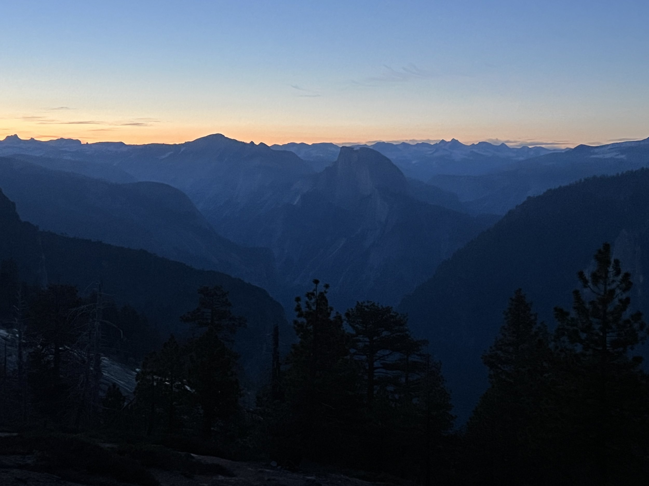
Sunrise from atop El Capitan
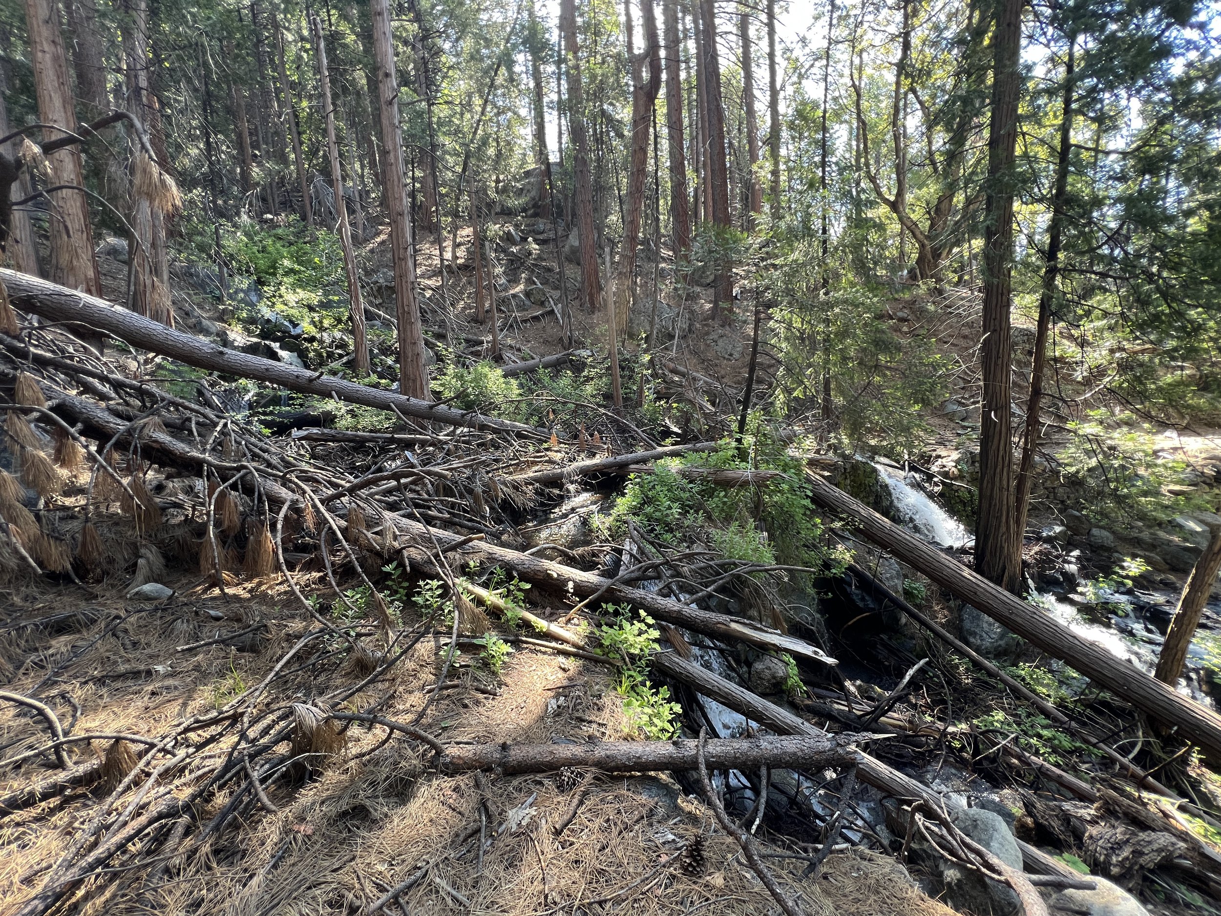
Rockslide Trail (original Big Oak Flat Road) littered with blowdowns.
View towards the bottom of the Rockslides Trail dropping into the Valley.

Building storm from atop Stanford Point
Day 3
Daily Miles: 13.6
Total Miles: 56.64
Daily Elevation Ascended: 1531
Daily Elevation Descended: 5067
It was a windy night and I woke up many times throughout. Up at 4:15 and on the trail in 30 minutes today by 4:45. Cowboy camping is the best.
In no time at all light started to fill the sky and nautical twilight woke the birds. It was only about 2.5 miles to Glacier Point and I was excited to have breakfast there. The Glacier Point Road doesn’t open until 7/1 this year so my expectation was that there would be a few other intrepid hikers there for sunrise.
I took a break as civil twilight began, listened to the birdsong, got peeks at the three falls of Yosemite Falls and finally arrived at the path to Glacier Point. As I arrived it was silent. Even though I felt it was impossible, I had a gut feeling I was alone. I decided to video my approach to the top. As I got closer and closer it was evident that I was indeed alone at the top of this famous precipice and gaining the peak I was rewarded with amazing 300 degree views.
I enjoyed some time out of my shoes with a mocha and breakfast before heading out on one of my favorite trails in the park. The Panorama Trail.
This was the final leg of my journey and I was sure I’d start seeing others soon. In no time at all a few trail runners passed me going the same direction. They all had come up the grueling 4-Mile trail and were coming down the Panorama and the Mist trails back to the valley. I love how this section gives rarely seen angular views of Half Dome all framed in lush green low growth with towering pines breaking the view into fragments of distance. I took many breaks on my way past Illilouette Falls and Creek. A couple packhorse teams passed me with the mules carrying side by side chainsaws.
I stopped for just a bit at Nevada Falls but the crowds of people had me on the move once again. I stopped to take pictures and video of the massive amounts of water coming out of the bottoms of both Nevada and Vernal Falls before hitting the valley floor soaking wet. The Mist Trail is no joke in the Spring and Summer of 2023.
An amazing training trip. A loop that one part of me is surprised others don’t do while another part of me understands the 25,653 vertical feet might be the reason.
The Fissures on Taft Point
Alone on Glacier Point for breakfast
View from Glacier Point, Vernal Falls and Nevada Falls
View into the upper valley
Illilouette Creek and Bridge
Nevada Falls
Nevada Falls up close
Vernal Falls